Earlier we attempted box cores where the piston and megacore had failed and surprise surprise all three of those failed too. So we collected autosub which had done an 8hr mission mapping the seafloor inside and outside of the "Haddock Box" (an area of voluntary closure to bottom trawling and longlines to try and regenerate stocks of haddock fry) where we were hoping to compare the species diversity in the trawled and non trawled areas. We then managed to get the ROV in for a couple of hours running a transect inside the box to ground truth the acoustic data. However with worsening weather once again we could not do a transect outside of the box in a trawled area. With any luck we'll be able to return again at the end of the trip to complete this, otherwise we shall have to make do with only a complete set of monochrome autosub photos from 15m above the whole area which do at least give you an idea of the life that may be seen on both sides of the box.
Right now we are leaving the southern end of rockall bank and heading on the 8hr journey up into the northern end where there is a bit more inside and outside protected area autosub mapping and ROV transects to do, along with the ROV transects I'm here to get around the eastern and north eastern cliffs of Rockall Bank. There is a lot of ROVing to come, so fingers crossed the weather finally lets up by tomorrow so that we can get down to it all.

The polygonal faults (a bit of a rubbish photo of the multibeam bathymetry). The purple are the higher plateaus and the green to red areas are the fault channels. The little lines are some of the transects where we have run the ROV. The polygonal plateau at the bottom of this image is 2km across.
 A sub-bottom profile image of a fault between polygonal plateaus.
 This is Aggie in the cold lab where we were performing geochemical tests inside a glove bag filled with nitrogen to avoid air contamination of the split cores of sediment obtained at the polygonal faults.
 When transiting to the rockall bank, many people could be found chilling out (and often assume this sort of position in the corner of the main lab between science activities even when we are on site!). This person has asked to remain anonymous, but I can confirm they were asleep... :)
 Problems in Rockall 1: this megacore should not be coming up with cylinders full of water (or emptying as they come out of the water) in an ideal world they would have been filled with sediment.
 Problems in Rockall 2: this piston core should be straight! I took this picture after they cut off the end of it to get the 49cm of sediment they did manage to catch with this 12m corer, so it actually was more bent than this! This steel barrel bent upon impact with a hard surface that we didn't expect to be there.
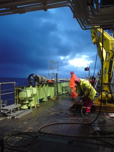 Start of shift at 4am on Rockall Bank and the clouds are closing in again and the wind starting to whip up again. End of play is called once again.
 A bit of bad weather downtime is a good excuse for a quick viewing of Despicable Me in the main lab (Ben in the orange is here watching this cartoon movie for the 3rd time in 12hours!).
No comments:
Post a Comment